Welcome Visitors
Dedicated to amateur meteorology, hydrology, botany and zoology of a suburban wetland, the field station employs consumer and hobbyist technology to collect, record and disseminate observations through methods that are both sound and easily replicable.
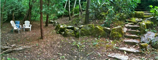
The station headquarters occupy the lowest level of a steeply sloped residential lot, in-fill that is the product of Portland's urban growth boundary.
The headquarters property was reclaimed from an overgrowth of blackberries through a lengthy process started in 2007. See HowToKillBlackberries. Then in 2009 an observation trail was extended along the creek to the wetland.
Recent Events
- Sep 4 -- Entertained Sculptor/Technologist BjClark in the field station welcome center. I hope he says nice things about us, especially to his dad, a practicing field biologist.
- Jul 30 -- RichGibson and WilliamAegerter brought their respective high-resolution photographic equipment to study various materials including some from the field.
- Sep 18 -- JdHuntington visited our field station. Kudos to JD for braving our disintegrating trail.
- Aug 29 -- One time neighbor, GeoffFalkenberg, recalls the creek as he knew it growing up across the street.
- May 23 -- We've stepped up our attack on EnglishIvy, an invasive plant slowly killing the trees along the Wiki Creek trail.
- May 16 -- We have become aware of AprilHillPark's Habitat Management & Trail Plan. We and they are adjacent tributaries to WoodsCreek, separated by a county line, municipality boundary, and, separate parks departments.
- April 10 -- Spring greening with the still open views has us thinking of StitchedPanoramas. This lead to creating mechanisms for FixpointPanorama which we've dubbed the WikiPod.
- January 2 -- Prof. PaulCuff visited our field station.
- MoreEvents -- Our archive goes back to the founding of the station.
- AreaSurveys -- We periodically survey the Wiki Creek and surrounding area for plants, animals or whatever else interests us.
- FannoCreekHeadwaters -- Elevation studies conducted initially with Google Earth, show Wiki Creek as headwaters to Fanno Creek and part of the Tualatin River drainage. Study includes 3-D images.
- WikiCreekPond -- We will photograph the wetland pond from the same vantage point at least four times a year.
- WikiCreekMeadow -- This level and open ground, bounded on the west by our pond, and on the north by FannoCreek, has been dubbed the "meadow".
- SiteKudos -- Unsolicited observations and complements about the field station and its accompanying web site.
- http:changes.cgi -- Use this link to list recent changes to this site.
Return to WelcomeVisitors